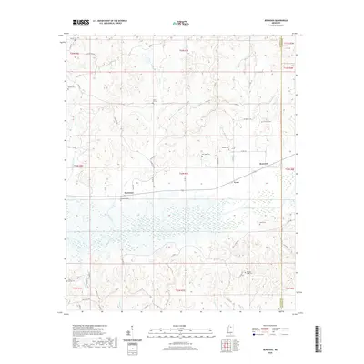
2020 Map of Benwood
USGS Topo · Published 2020About this map
The Skuna River bottomlands define the southern half of this landscape, where a dense network of seasonal wetlands and creeks like York Creek and Spearman Creek flow through the Yalobusha and Calhoun county borderlands. Small rural hubs such as Spearman and Benwood are connected by a system of country roads including Air Mount E Rd and Pine Grove Rd. For those researching local family history, the map is remarkably dense with burial sites. A dozen named cemeteries are distributed across these hills, including Haven Hill Cem, Arimount Cem, and the remote Dividing Ridge Cem further south. This distribution reflects the longstanding pattern of small, family-centered settlements that have persisted in this part of Mississippi into the modern era.
Find a feature on this map
66 named features on this map. Tap any name to fly to it.
Don’t see what you’re looking for? This feature index may not catch every label — zoom into the map to look around manually.
Map Details
Editions of this 2020 Benwood Map
This is the sole edition of this map. No revisions or reprints were ever made.
Other maps of this area

1953 · West Point
USGS Topo · 1:250,000

1954 · Pittsboro
USGS Topo · 1:62,500

1954 · Water Valley
USGS Topo · 1:62,500

1955 · Water Valley
USGS Topo · 1:62,500

1955 · Coffeeville
USGS Topo · 1:62,500

1956 · Tupelo
USGS Topo · 1:250,000

1958 · Tupelo
USGS Topo · 1:250,000

1958 · West Point
USGS Topo · 1:250,000

1963 · West Point
USGS Topo · 1:250,000
1971 · Coffeeville
USGS Topo · 1:24,000