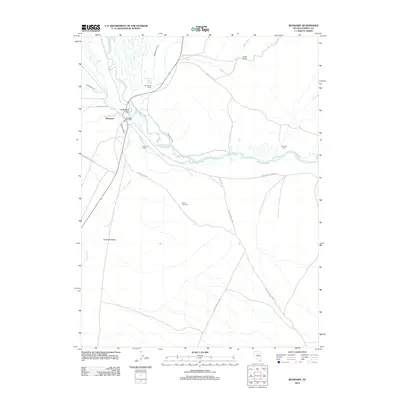
2012 Map of Beowawe
USGS Topo · Published 2012About this map
The Humboldt River snakes through this high desert landscape, serving as the historical and agricultural lifeline for northern Nevada. Near the settlement of Beowawe, the river valley supports a network of irrigation works including the Anderson Canal, Highline Canal, and Westside Ditch. These water systems sustain established holdings like the Horseshoe Ranch and Johnson Ranch.
Find a feature on this map
26 named features on this map. Tap any name to fly to it.
Don’t see what you’re looking for? This feature index may not catch every label — zoom into the map to look around manually.
Map Details
Editions of this 2012 Beowawe Map
This is the sole edition of this map. No revisions or reprints were ever made.
Other maps of this area

1949 · Crescent Valley
USGS Topo · 1:62,500

1950 · Crescent Valley
USGS Topo · 1:62,500

1955 · Winnemucca
USGS Topo · 1:250,000

1957 · Frenchie Creek
USGS Topo · 1:62,500

1957 · Dunphy
USGS Topo · 1:62,500

1957 · Beowawe
USGS Topo · 1:62,500

1958 · Winnemucca
USGS Topo · 1:250,000

1962 · Winnemucca
USGS Topo · 1:250,000

1985 · Scotts Gulch
USGS Topo · 1:24,000
1985 · Crescent Valley
USGS Topo · 1:24,000