
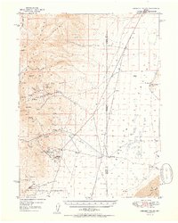
1950 Map of Crescent Valley
USGS Topo · Published 1950About this map
Crescent Valley and the Shoshone Range define this high desert landscape, captured here in 1950 during a period of transition for Nevada's mining districts. The map documents an industrial shift, noting active operations like the Gold Acres Mine and Gold Acres settlement alongside several sites already marked as inactive. These dormant locations, including the Mud Spring Mine, Lovie Mine, and Tomcat Mine, trace the earlier booms of the region. The map also identifies the Lander (Site), suggesting a settlement that had already faded from prominence by the mid-century. Away from the mountain slopes, the valley floor is characterized by expansive cattle operations like the Dean Ranch and several geothermal features such as Hot Springs and Hot Springs Point, reflecting the complex geology that fueled the area's mineral wealth and rural economy.
Find a feature on this map
38 named features on this map. Tap any name to fly to it.
Don’t see what you’re looking for? This feature index may not catch every label — zoom into the map to look around manually.
Map Details
Editions of this 1950 Crescent Valley Map
2 editions found
Other maps of this area

1938 · Cortez
USGS Topo · 1:48,000

1944 · Cortez
USGS Topo · 1:62,500

1949 · Crescent Valley
USGS Topo · 1:62,500

1949 · Mt. Lewis
USGS Topo · 1:62,500

1950 · Mt. Lewis
USGS Topo · 1:62,500

1955 · Winnemucca
USGS Topo · 1:250,000

1957 · Frenchie Creek
USGS Topo · 1:62,500

1957 · Dunphy
USGS Topo · 1:62,500

1957 · Beowawe
USGS Topo · 1:62,500

1957 · Horse Creek Valley
USGS Topo · 1:62,500