
1944 Map of Cortez
USGS Topo · Published 1944About this map
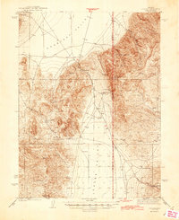
Cortez sits at the foot of the Cortez Mountains in this 1938 survey of Lander and Eureka counties. The landscape is defined by the extraction economy of the mid-20th century, centered on the Cortez Mine and the Mill Canyon Mine. The rugged topography is interspersed with isolated signs of settlement, including the Mill Canyon Sch and remote dwellings like Francis Cabin and Rock House.
Find a feature on this map
29 named features on this map. Tap any name to fly to it.
Don’t see what you’re looking for? This feature index may not catch every label — zoom into the map to look around manually.
Map Details
Editions of this 1944 Cortez Map
2 editions found
Other maps of this area

1926 · Roberts Mountains
USGS Topo · 1:250,000

1929 · Roberts Mountains
USGS Topo · 1:250,000

1938 · Cortez
USGS Topo · 1:48,000

1949 · Crescent Valley
USGS Topo · 1:62,500

1949 · Mt. Lewis
USGS Topo · 1:62,500

1949 · Roberts Creek Mtn
USGS Topo · 1:62,500

1950 · Mt. Lewis
USGS Topo · 1:62,500

1950 · Crescent Valley
USGS Topo · 1:62,500

1951 · Roberts Creek Mtn
USGS Topo · 1:62,500

1955 · Millett
USGS Topo · 1:250,000