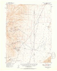
1950 Map of Crescent Valley
USGS Topo · Published 1950About this map
Mining operations and ranching life define this mid-century survey of the rugged Nevada landscape straddling the Lander Co Eureka Co border. Significant focus is placed on the extraction hubs of the Shoshone and Cortez ranges, where the large-scale Gold Acres Mine and associated Gold Acres settlement stand in contrast to dozens of smaller prospects and inactive workings like the Tomcat Mine. These labels suggest a region in transition, moving from the smaller silver and gold strikes of the previous century to more industrialized operations.
Find a feature on this map
40 named features on this map. Tap any name to fly to it.
Don’t see what you’re looking for? This feature index may not catch every label — zoom into the map to look around manually.
Map Details
Editions of this 1950 Crescent Valley Map
2 editions found
Other maps of this area

1938 · Cortez
USGS Topo · 1:48,000

1944 · Cortez
USGS Topo · 1:62,500

1949 · Crescent Valley
USGS Topo · 1:62,500

1949 · Mt. Lewis
USGS Topo · 1:62,500

1950 · Mt. Lewis
USGS Topo · 1:62,500

1950 · Crescent Valley
USGS Topo · 1:62,500

1955 · Winnemucca
USGS Topo · 1:250,000

1957 · Frenchie Creek
USGS Topo · 1:62,500

1957 · Dunphy
USGS Topo · 1:62,500

1957 · Beowawe
USGS Topo · 1:62,500