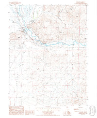
1986 Map of Beowawe
USGS Topo · Published 1986About this map
The Humboldt River carves through this high-desert Nevada landscape, serving as the primary corridor for movement and settlement near Beowawe. This mid-1980s provisional survey shows a terrain defined by broad valley floors and extractive industry, with the Whirlwind Valley to the north and the expansive Crescent Valley to the south. Small-scale ranching and mineral exploration are evident in features like Horseshoe Ranch and the Red Devil Mine, while a small Cem stands near the riverbank, providing a point of interest for genealogists tracking early residents. The map documents various water sources essential to this arid region, including a Hot Spring, Bob Creek, and an Artesian Well. The presence of the Location Trail and numerous scattered Prospect sites reflects the area's continued history of mining and surveying along the river's northern banks.
Find a feature on this map
24 named features on this map. Tap any name to fly to it.
Don’t see what you’re looking for? This feature index may not catch every label — zoom into the map to look around manually.
Map Details
Editions of this 1986 Beowawe Map
This is the sole edition of this map. No revisions or reprints were ever made.
Other maps of this area

1949 · Crescent Valley
USGS Topo · 1:62,500

1950 · Crescent Valley
USGS Topo · 1:62,500

1955 · Winnemucca
USGS Topo · 1:250,000

1957 · Frenchie Creek
USGS Topo · 1:62,500

1957 · Dunphy
USGS Topo · 1:62,500

1957 · Beowawe
USGS Topo · 1:62,500

1958 · Winnemucca
USGS Topo · 1:250,000

1962 · Winnemucca
USGS Topo · 1:250,000

1985 · Scotts Gulch
USGS Topo · 1:24,000
1985 · Crescent Valley
USGS Topo · 1:24,000