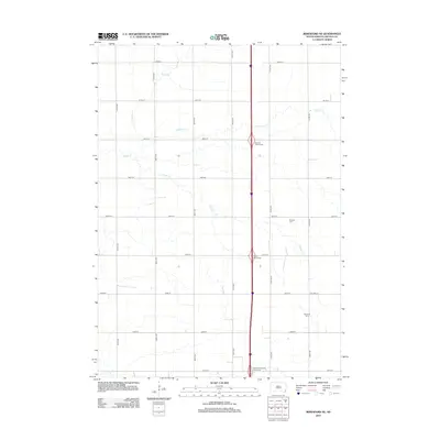
2012 Map of Beresford NE
USGS Topo · Published 2012About this map
The rolling plains of Lincoln County are defined by a rhythmic grid of rural roads and the wandering paths of prairie streams. Several tributaries, including Snake Cr, Saddle Cr, and Haram Cr, cut through the section lines, shaping the agricultural landscape north of Beresford. This 2012 survey captures the area as a modern transportation corridor, dominated by a north-south interstate featuring several major access points such as the Fairview Interchange and Viborg Interchange. For those tracing local heritage, the map identifies small but significant cultural sites including the Pioneer Cem and Nazareth Cem, which serve as quiet markers of the families who established the farming communities in this portion of South Dakota.
Find a feature on this map
25 named features on this map. Tap any name to fly to it.
Don’t see what you’re looking for? This feature index may not catch every label — zoom into the map to look around manually.
Map Details
Editions of this 2012 Beresford NE Map
This is the sole edition of this map. No revisions or reprints were ever made.
Other maps of this area

1897 · Canton
USGS Topo · 1:125,000

1900 · Canton
USGS Topo · 1:125,000

1955 · Sioux Falls
USGS Topo · 1:250,000

1958 · Sioux Falls
USGS Topo · 1:250,000

1964 · Canton SW
USGS Topo · 1:24,000

1964 · Worthing
USGS Topo · 1:24,000

1964 · Lennox
USGS Topo · 1:24,000

1968 · Alcester NW
USGS Topo · 1:24,000
1968 · Alcester
USGS Topo · 1:24,000
1968 · Beresford NW
USGS Topo · 1:24,000
Featured Places
- Brooklyn Township, SD
- Lincoln Township, SD
- Delaware Township, SD
- Pleasant Township, SD
- Lincoln County, SD