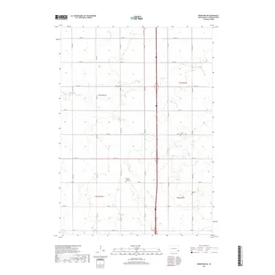
2017 Map of Beresford NE
USGS Topo · Published 2017About this map
Small rural congregations and their adjoining burial grounds anchor this agricultural landscape in Lincoln County. The drainage patterns of Snake Cr and Saddle Cr dictate the layout of the local road network, which primarily follows a rigid section-line grid. Significant landmarks for genealogists include the Skrefsrud Lutheran Church and its associated Skrefsrud Lutheran Cem near the center of the survey. To the east, the Pioneer Church and Pioneer Cem serve as historical focal points for the farming community near the upper reaches of Haram Cr. The map captures a quiet, high-plains landscape where traditional land divisions remain largely unchanged, preserving the sites of early Scandinavian and pioneer settlement. Further south, the Nazareth Cem provides another point of interest for those tracing family roots in this corner of South Dakota.
Find a feature on this map
28 named features on this map. Tap any name to fly to it.
Don’t see what you’re looking for? This feature index may not catch every label — zoom into the map to look around manually.
Map Details
Editions of this 2017 Beresford NE Map
This is the sole edition of this map. No revisions or reprints were ever made.
Other maps of this area
1897 · Canton
USGS Topo · 1:125,000
1900 · Canton
USGS Topo · 1:125,000
1955 · Sioux Falls
USGS Topo · 1:250,000
1958 · Sioux Falls
USGS Topo · 1:250,000
1964 · Canton SW
USGS Topo · 1:24,000
1964 · Worthing
USGS Topo · 1:24,000
1964 · Lennox
USGS Topo · 1:24,000
1968 · Alcester NW
USGS Topo · 1:24,000
1968 · Alcester
USGS Topo · 1:24,000
1968 · Beresford NW
USGS Topo · 1:24,000
Featured Places
- Brooklyn Township, SD
- Lincoln Township, SD
- Delaware Township, SD
- Pleasant Township, SD
- Lincoln County, SD