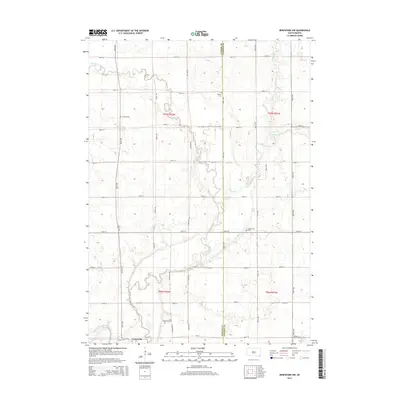
2015 Map of Beresford NW
USGS Topo · Published 2015About this map
The Vermillion River meanders through this agricultural landscape on the border of Turner and Lincoln Counties, defining the drainage patterns of the region. Near the southern edge of the survey, the settlement of Centerville serves as a local hub where Turkey Ridge Cr joins the larger river system. The land is partitioned by an extensive section-line road grid, including Riverview Ave and 464th Ave, which connect several longstanding community landmarks. Genealogists will find several burial sites preserved across these townships, such as Frieling Cem, Melhus Cem, and Mount Zion Cem. The presence of Mears Ditch and tributaries like Long Cr and Saddle Cr illustrate the complex water management required for this prairie environment. This record of the mid-2010s shows a landscape still deeply rooted in its rural township structure, with family and community history etched into the small cemeteries and creek crossings that dot the terrain.
Find a feature on this map
33 named features on this map. Tap any name to fly to it.
Don’t see what you’re looking for? This feature index may not catch every label — zoom into the map to look around manually.
Map Details
Editions of this 2015 Beresford NW Map
This is the sole edition of this map. No revisions or reprints were ever made.
Other maps of this area

1897 · Canton
USGS Topo · 1:125,000

1898 · Parker
USGS Topo · 1:125,000

1900 · Canton
USGS Topo · 1:125,000

1955 · Sioux Falls
USGS Topo · 1:250,000

1958 · Sioux Falls
USGS Topo · 1:250,000

1964 · Worthing
USGS Topo · 1:24,000

1964 · Lennox
USGS Topo · 1:24,000
1968 · Beresford NW
USGS Topo · 1:24,000
1968 · Beresford
USGS Topo · 1:24,000
1968 · Hurley
USGS Topo · 1:24,000
Featured Places
- Centerville Township, SD
- Turner Township, SD
- Brooklyn Township, SD
- Delaware Township, SD
- Lincoln County, SD