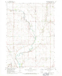
1968 Map of Beresford NW
USGS Topo · Published 1971About this map
Turkey Ridge rises above the southeastern South Dakota prairie in this late 1960s landscape, where the Vermillion River meanders through a network of small agricultural townships including Turner, Delaware, and Brooklyn. The city of Centerville serves as the primary hub, situated near the Chicago and North Western rail line and Gunderson Park. The survey captures a well-established rural community defined by its local institutions, featuring numerous country schools such as Faith Sch and Pleasant Grove Sch. Genealogists will find significant value in the distribution of family-connected burial grounds like Frieling Cem, Melhus Cem, and Riverview Cem. Industrial and transport markers of the era include several Gravel Pits and private aviation facilities like the Nelson Landing Strip and Overgaard Airport.
Find a feature on this map
32 named features on this map. Tap any name to fly to it.
Don’t see what you’re looking for? This feature index may not catch every label — zoom into the map to look around manually.
Map Details
Editions of this 1968 Beresford NW Map
This is the sole edition of this map. No revisions or reprints were ever made.
Other maps of this area

1897 · Canton
USGS Topo · 1:125,000

1898 · Parker
USGS Topo · 1:125,000

1900 · Canton
USGS Topo · 1:125,000

1955 · Sioux Falls
USGS Topo · 1:250,000

1958 · Sioux Falls
USGS Topo · 1:250,000

1964 · Worthing
USGS Topo · 1:24,000

1964 · Lennox
USGS Topo · 1:24,000
1968 · Beresford
USGS Topo · 1:24,000
1968 · Hurley
USGS Topo · 1:24,000
1968 · Beresford NE
USGS Topo · 1:24,000
Featured Places
- Delaware Township, SD
- Centerville Township, SD
- Brooklyn Township, SD
- Turner Township, SD
- Lincoln County, SD