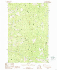
1988 Map of Berge Peak
USGS Topo · Published 1988About this map
The high mountain terrain of the Idaho-Montana border dominates this late 20th-century survey, specifically where Shoshone County meets Mineral County. The landscape is a complex network of high ridges and drainage basins, centered on the towering Berge Peak and the expansive Simmons Ridge. The map details the headwaters of numerous waterways, including Gold Creek and Simmons Creek, which carve deep valleys through the St. Joe and Lolo National Forests. High-altitude landmarks such as Flattop Mountain, Pegley Mountain, and Midget Peak serve as primary topographical markers for this remote wilderness area. A scattered network of a Pack Trail provides the only mapped overland access through these steep elevations, tracing routes past isolated water features like Moore Lake and Summit Springs. This provisional edition captures the pristine, undeveloped character of the Bitterroot Range before further modern infrastructure reached these high-elevation forest lands.
Find a feature on this map
27 named features on this map. Tap any name to fly to it.
Don’t see what you’re looking for? This feature index may not catch every label — zoom into the map to look around manually.
Map Details
Editions of this 1988 Berge Peak Map
This is the sole edition of this map. No revisions or reprints were ever made.
Other maps of this area

1918 · St Regis
USGS Topo · 1:125,000

1919 · St. Regis
USGS Topo · 1:125,000

1956 · St Regis
USGS Topo · 1:62,500

1956 · Wallace
USGS Topo · 1:250,000

1957 · Illinois Peak
USGS Topo · 1:62,500

1957 · Haugan
USGS Topo · 1:62,500

1957 · Simmons Peak
USGS Topo · 1:62,500

1960 · Wallace
USGS Topo · 1:250,000
1988 · Sherlock Peak
USGS Topo · 1:24,000
1988 · Peggy Peak
USGS Topo · 1:24,000