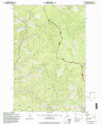
1995 Map of Berge Peak
USGS Topo · Published 1997About this map
St Joe National Forest and Lolo National Forest converge at the jagged Idaho Montana state line, a high-altitude border defined by the watershed of the Bitterroot Range. This mid-1990s survey by the Forest Service captures the remote topography where Shoshone County, Idaho, meets Mineral County, Montana. The landscape is dominated by notable heights such as Berge Peak, Pegleg Mountain, and Flattop Mountain. Drainage patterns are clearly marked by the headwaters of Simmons Creek and Gold Creek, which carve deep valleys through the timbered slopes. The Avery Superior Rd and the 9th Standard Parallel North provide the primary navigational framework for this backcountry area. High-elevation features like Moore Lake and Summit Springs offer specific points of interest for those studying the hydrology and natural landmarks of this interstate boundary region.
Find a feature on this map
30 named features on this map. Tap any name to fly to it.
Don’t see what you’re looking for? This feature index may not catch every label — zoom into the map to look around manually.
Map Details
Editions of this 1995 Berge Peak Map
This is the sole edition of this map. No revisions or reprints were ever made.
Other maps of this area

1918 · St Regis
USGS Topo · 1:125,000

1919 · St. Regis
USGS Topo · 1:125,000

1956 · St Regis
USGS Topo · 1:62,500

1956 · Wallace
USGS Topo · 1:250,000

1957 · Illinois Peak
USGS Topo · 1:62,500

1957 · Haugan
USGS Topo · 1:62,500

1957 · Simmons Peak
USGS Topo · 1:62,500

1960 · Wallace
USGS Topo · 1:250,000
1988 · Sherlock Peak
USGS Topo · 1:24,000
1988 · Peggy Peak
USGS Topo · 1:24,000