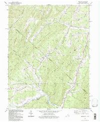
1994 Map of Bergton
USGS Topo · Published 1997About this map
Bergton sits along the North Fork Shenandoah River in this survey of the Virginia and West Virginia borderlands. The settlement serves as a focal point for local history researchers, featuring the Bergton Sch and several community landmarks like the Martin Luther Ch and the Bergton Gospel Center. The landscape is defined by the high ridges of Shenandoah Mountain and Flattop Mountain, which separate the river valley from the drainage of the Lost River to the east.
Find a feature on this map
42 named features on this map. Tap any name to fly to it.
Don’t see what you’re looking for? This feature index may not catch every label — zoom into the map to look around manually.
Map Details
Editions of this 1994 Bergton Map
This is the sole edition of this map. No revisions or reprints were ever made.
Other maps of this area

1892 · Franklin
USGS Topo · 1:125,000

1892 · Woodstock
USGS Topo · 1:125,000

1896 · Franklin
USGS Topo · 1:125,000

1920 · Petersburg
USGS Topo · 1:48,000

1921 · Orkney Springs
USGS Topo · 1:48,000

1921 · Petersburg
USGS Topo · 1:48,000

1922 · Fort Seybert
USGS Topo · 1:48,000

1922 · Petersburg
USGS Topo · 1:62,500

1923 · Orkney Springs
USGS Topo · 1:62,500

1924 · Fort Seybert
USGS Topo · 1:62,500