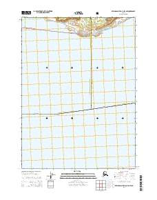
2014 Map of Bering Glacier A-8 OE S NW
USGS Topo · Published 2014About this map
Cape Suckling anchors the northern coastline on this coastal survey, where the Gulf of Alaska meets the southern edge of the Chugach National Forest. The map documents a sparsely settled maritime landscape defined by its administrative boundaries rather than infrastructure, marking the division between the Valdez-Cordova Census Area and the Yakutat City and Borough. This boundary transition is a primary feature of the sheet, cutting through the forest and coastal reaches. The terrain is marked by township markers t22s r8e and t22s r9e, showing the underlying public land survey system in this remote Alaskan wilderness. While human settlements are absent, the map provides precise topographic and hydrographic data for the shoreline and the wooded slopes of the national forest as they existed in the early twenty-first century.
Find a feature on this map
6 named features on this map. Tap any name to fly to it.
Don’t see what you’re looking for? This feature index may not catch every label — zoom into the map to look around manually.
Map Details
Editions of this 2014 Bering Glacier A-8 OE S NW Map
This is the sole edition of this map. No revisions or reprints were ever made.
Other maps of this area

1948 · Cordova
USGS Topo · 1:250,000

1948 · Middleton Island
USGS Topo · 1:250,000

1950 · Middleton Island
USGS Topo · 1:250,000

1950 · Bering Glacier
USGS Topo · 1:250,000

1950 · Icy Bay
USGS Topo · 1:250,000

1950 · Cordova A-1
USGS Topo · 1:63,360

1951 · Icy Bay
USGS Topo · 1:250,000

1951 · Bering Glacier
USGS Topo · 1:250,000

1951 · Cordova
USGS Topo · 1:250,000
1953 · Cordova A-1
USGS Topo · 1:63,360