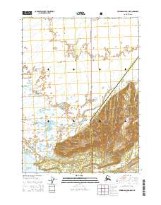
2014 Map of Bering Glacier A-8 SW
USGS Topo · Published 2014About this map
The coastal wilderness within the Chugach National Forest dominates this topographic study, where the eastern edge of the Valdez-Cordova Census Area meets the Yakutat City and Borough. This remote segment of the Alaskan coastline is defined by the shifting braids of the Okalee River, which winds across the glacial outwash plain before reaching the Gulf of Alaska. The landscape represents a complex hydrological network where the Kiklukh River and numerous unnamed tributaries navigate the low-lying terrain south of the glacial highlands. The map provides a detailed view of the Public Land Survey System grid, including townships t21s r8e and t21s r9e, illustrating how administrative boundaries are superimposed over this undeveloped glacial landscape at the start of the twenty-first century.
Find a feature on this map
11 named features on this map. Tap any name to fly to it.
Don’t see what you’re looking for? This feature index may not catch every label — zoom into the map to look around manually.
Map Details
Editions of this 2014 Bering Glacier A-8 SW Map
This is the sole edition of this map. No revisions or reprints were ever made.
Other maps of this area

1948 · Cordova
USGS Topo · 1:250,000

1948 · Middleton Island
USGS Topo · 1:250,000

1950 · Middleton Island
USGS Topo · 1:250,000

1950 · Bering Glacier
USGS Topo · 1:250,000

1950 · Icy Bay
USGS Topo · 1:250,000

1950 · Cordova A-1
USGS Topo · 1:63,360

1951 · Icy Bay
USGS Topo · 1:250,000

1951 · Bering Glacier
USGS Topo · 1:250,000

1951 · Cordova
USGS Topo · 1:250,000
1953 · Cordova A-1
USGS Topo · 1:63,360