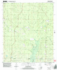
2002 Map of Berlin
USGS Topo · Published 2003About this map
The Arkansas-Louisiana state line divides this territory where Ashley County and Morehouse Parish meet. This early 21st-century update shows a landscape defined by its creek systems, including the winding Chemin-A-Haut Creek and the wetlands around Bayou Chemin-A-Haut. Small settlements and social centers are scattered throughout the quadrangle, notably at Berlin, Gulledge, and Rawls. These communities are anchored by several local churches such as Corinth Ch, Mapleville Ch, and Mt Zion Ch, which often serve as the primary landmarks for researchers and genealogists tracing family roots in this rural borderland.
Find a feature on this map
19 named features on this map. Tap any name to fly to it.
Don’t see what you’re looking for? This feature index may not catch every label — zoom into the map to look around manually.
Map Details
Editions of this 2002 Berlin Map
This is the sole edition of this map. No revisions or reprints were ever made.
Other maps of this area

1935 · Wilmot
USGS Topo · 1:62,500

1935 · Naff
USGS Topo · 1:62,500

1935 · Bonita
USGS Topo · 1:62,500

1953 · Greenwood
USGS Topo · 1:250,000

1955 · Jackson
USGS Topo · 1:250,000

1956 · Greenwood
USGS Topo · 1:250,000

1956 · Bastrop
USGS Topo · 1:62,500

1958 · Bonita
USGS Topo · 1:62,500

1960 · Wilmot
USGS Topo · 1:62,500

1960 · Wilmot NW
USGS Topo · 1:24,000