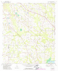
1978 Map of Berlin West
USGS Topo · Published 1988About this map
Okapilco Creek and its many tributaries, including Hog Creek and Little Creek, define the landscape of south-central Georgia during the late 1970s. The map illustrates a rural society organized around crossroads communities and numerous country congregations. Notable religious landmarks such as Hopewell Ch, Sardis Ch, and Wesley Chapel serve as anchor points across the undulating terrain. A distinct educational history is preserved in the location of the Culbertson Sch near Evelyn. The interaction of infrastructure and agriculture is evident in the Pipeline corridor and a small Landing Strip that cut through the woodlands and fields. Along the eastern edge, the settlement of Berlin represents the primary population center, while smaller locales like Ione and Troy reflect the dispersed settlement pattern characteristic of Colquitt Co and its neighbors during this era of photorevised mapping.
Find a feature on this map
28 named features on this map. Tap any name to fly to it.
Don’t see what you’re looking for? This feature index may not catch every label — zoom into the map to look around manually.
Map Details
Editions of this 1978 Berlin West Map
2 editions found
Other maps of this area

1953 · Waycross
USGS Topo · 1:250,000

1954 · Valdosta
USGS Topo · 1:250,000

1957 · Thomasville
USGS Topo · 1:62,500

1958 · Valdosta
USGS Topo · 1:250,000

1958 · Waycross
USGS Topo · 1:250,000

1959 · Valdosta
USGS Topo · 1:250,000

1961 · Quitman
USGS Topo · 1:62,500

1974 · Berlin East
USGS Topo · 1:24,000

1974 · Pineboro
USGS Topo · 1:24,000
1974 · Ellenton
USGS Topo · 1:24,000