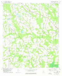
1978 Map of Berlin West
USGS Topo · Published 1978About this map
Okapilco Creek and its tributaries, including Little Okapilco Creek and Hog Creek, form the central drainage system of this South Georgia landscape. The area is characterized by a dense network of country churches and rural school sites that served the local agricultural community, such as New Jerusalem Ch and Culbertson Sch. Near the community of Berlin, the Georgia Northern Railroad cuts through the terrain, illustrating the logistical importance of rail transport for the region's timber and farming interests during the late 1970s. The convergence of three counties—Colquitt, Thomas, and Brooks—is a notable jurisdictional landmark in the southwestern portion of the sheet. Genealogists will find significant value in the documentation of several family and community burial grounds, including the Wesley Chapel Cem and Sardis Ch Cem, which remain as permanent markers of the area's ancestral settlement patterns.
Find a feature on this map
33 named features on this map. Tap any name to fly to it.
Don’t see what you’re looking for? This feature index may not catch every label — zoom into the map to look around manually.
Map Details
Editions of this 1978 Berlin West Map
2 editions found
Other maps of this area

1953 · Waycross
USGS Topo · 1:250,000

1954 · Valdosta
USGS Topo · 1:250,000

1957 · Thomasville
USGS Topo · 1:62,500

1958 · Valdosta
USGS Topo · 1:250,000

1958 · Waycross
USGS Topo · 1:250,000

1959 · Valdosta
USGS Topo · 1:250,000

1961 · Quitman
USGS Topo · 1:62,500

1974 · Berlin East
USGS Topo · 1:24,000

1974 · Pineboro
USGS Topo · 1:24,000
1974 · Ellenton
USGS Topo · 1:24,000