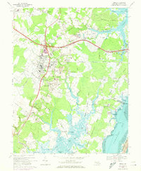
1967 Map of Berlin
USGS Topo · Published 1973About this map
The town of Berlin serves as the focal point of this coastal Maryland landscape, where the Penn Central and Maryland and Eastern Railroad once converged. The survey highlights the deep local history through landmarks like the Stephen Decatur Monument and several historic educational sites, including the St Pauls Flower St Sch and Buckingham Sch. To the south and east, the terrain transitions into a complex system of waterways and peninsulas, including Upper Sinepuxent Neck and Golden Quarter Neck, leading toward Sinepuxent Bay and the edge of Assateague Island. Smaller outlying settlements such as Ironshire, Germantown, and Trappe are connected by a network of rural roads like Georgetown Road, while the landscape is dotted with numerous sandpits and localized water bodies such as Bassett Millpond and Silver Lake.
Find a feature on this map
84 named features on this map. Tap any name to fly to it.
Don’t see what you’re looking for? This feature index may not catch every label — zoom into the map to look around manually.
Map Details
Editions of this 1967 Berlin Map
3 editions found
Other maps of this area

1901 · Snow Hill
USGS Topo · 1:62,500

1901 · Green Run
USGS Topo · 1:62,500

1901 · Ocean City
USGS Topo · 1:62,500

1902 · Pittsville
USGS Topo · 1:62,500

1938 · Green Run
USGS Topo · 1:62,500

1942 · Ocean City
USGS Topo · 1:62,500

1942 · Ninepin
USGS Topo · 1:24,000

1942 · Ocean City
USGS Topo · 1:24,000

1942 · Tingles Island
USGS Topo · 1:24,000

1942 · Wesley
USGS Topo · 1:24,000