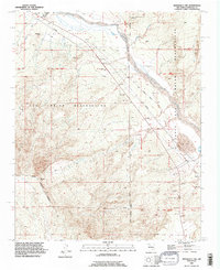
1990 Map of Bernalillo NW
USGS Topo · Published 1996About this map
Zia Pueblo Indian Reservation and Santa Ana Pueblo Indian Reservation converge in this arid landscape, where the Jemez River carves a path through the sandstone terrain. The land is defined by drainage systems such as Arenoso Arroyo and Ojito Arroyo, which cut across the high desert flats. To the east, a cluster of Sand Dunes stands near the riverbank, indicating the active shifting of sediments in this drainage basin.
Find a feature on this map
13 named features on this map. Tap any name to fly to it.
Don’t see what you’re looking for? This feature index may not catch every label — zoom into the map to look around manually.
Map Details
Editions of this 1990 Bernalillo NW Map
This is the sole edition of this map. No revisions or reprints were ever made.
Other maps of this area

1888 · Bernalillo
USGS Topo · 1:125,000

1889 · Albuquerque
USGS Topo · 1:125,000

1890 · Jemes
USGS Topo · 1:125,000

1892 · Jemes
USGS Topo · 1:125,000

1893 · Albuquerque
USGS Topo · 1:125,000

1939 · San Ysidro
USGS Topo · 1:62,500

1943 · San Ysidro
USGS Topo · 1:62,500

1943 · Jemez
USGS Topo · 1:62,500

1952 · Jemez
USGS Topo · 1:62,500

1953 · Bernalillo NW
USGS Topo · 1:24,000