
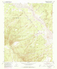
1953 Map of Bernalillo NW
USGS Topo · Published 1955About this map
Zia Indian Reservation and the adjacent Zia Pueblo Grant dominate this mid-century landscape in Sandoval County, defined by the seasonal dynamics of the Jemez River. The map reveals a transition in transportation and infrastructure, most notably the path of an Old Railroad Grade and a long-distance Telephone Line cutting diagonally across the high desert terrain. Scattered ranching and industrial markers like the Jemez Windmill and a localized Gravel Pit suggest a sparse but active utilization of the land. In the eastern portion of the sheet, the river's influence is seen in the shifting Sand Dunes and a designated Spillway Elevation 5232, reflecting mid-century water management efforts. Several sections of the Reservation Boundary are noted as approximate, providing a record of jurisdictional demarcations during the early 1950s.
Find a feature on this map
17 named features on this map. Tap any name to fly to it.
Don’t see what you’re looking for? This feature index may not catch every label — zoom into the map to look around manually.
Map Details
Editions of this 1953 Bernalillo NW Map
2 editions found
Other maps of this area

1888 · Bernalillo
USGS Topo · 1:125,000

1889 · Albuquerque
USGS Topo · 1:125,000

1890 · Jemes
USGS Topo · 1:125,000

1892 · Jemes
USGS Topo · 1:125,000

1893 · Albuquerque
USGS Topo · 1:125,000

1939 · San Ysidro
USGS Topo · 1:62,500

1943 · San Ysidro
USGS Topo · 1:62,500

1943 · Jemez
USGS Topo · 1:62,500

1952 · Jemez
USGS Topo · 1:62,500

1954 · Loma Machete
USGS Topo · 1:24,000