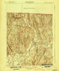
1941 Map of Bernardston
USGS Topo · Published 1941About this map
Bernardston sits at a geographic crossroads in Franklin County, where the valley of the Falls River cuts through a landscape dominated by prominent heights like Wildcat Mtn and Bald Mtn. During this era, the region maintained a strong rural character, evidenced by the high density of district schools including Beaver Meadow Sch, East Hill Sch, and Bald Mountain Sch. The Boston and Maine railroad tracks follow the river's path, passing through Hales Crossing, a vital link for the local economy. To the west, the Greenfield Filter Plant and Greenfield Reservoir indicate the growing infrastructure needs of the neighboring township. The terrain is marked by numerous family-named peaks and winding local roads such as Lovers Lane and Lambblack Road, while the eastern edge is defined by the Northfield State Forest.
Find a feature on this map
51 named features on this map. Tap any name to fly to it.
Don’t see what you’re looking for? This feature index may not catch every label — zoom into the map to look around manually.
Map Details
Editions of this 1941 Bernardston Map
3 editions found
Other maps of this area

1887 · Warwick
USGS Topo · 1:62,500

1889 · Warwick
USGS Topo · 1:62,500

1890 · Greenfield
USGS Topo · 1:62,500

1891 · Brattleboro
USGS Topo · 1:62,500

1893 · Brattleboro
USGS Topo · 1:62,500

1894 · Greenfield
USGS Topo · 1:62,500

1894 · Warwick
USGS Topo · 1:62,500

1898 · Keene
USGS Topo · 1:62,500

1932 · Brattleboro
USGS Topo · 1:48,000

1932 · Warwick
USGS Topo · 1:48,000