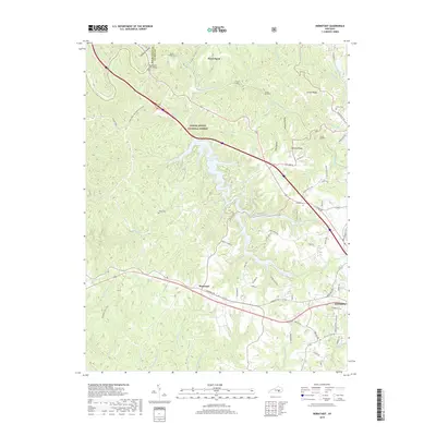
2019 Map of Bernstadt
USGS Topo · Published 2019About this map
Bernstadt and the western outskirts of London anchor this landscape where the Daniel Boone National Forest meets residential expansion. The terrain is defined by deeply carved hollows and prominent ridges like Arthur Ridge and Johnson Ridge, which channel the flow of numerous waterways toward the Rockcastle River. Significant modern engineering is visible in the form of Wood Creek Lake and the various railway tunnels, including Tunnel Number 7 and Tunnel Number 8, that navigate the complex topography. Historically minded researchers can find small family burial grounds such as Snuffer Cem, Andes Cem, and Whitt Cem tucked away from the main thoroughfares. The road network, including Somerset Rd and N Laurel Rd, connects the older settlement of Hazel Patch to newer developments like Dogwood Hills, illustrating the continued transition of this Kentucky highland region.
Find a feature on this map
77 named features on this map. Tap any name to fly to it.
Don’t see what you’re looking for? This feature index may not catch every label — zoom into the map to look around manually.
Map Details
Editions of this 2019 Bernstadt Map
This is the sole edition of this map. No revisions or reprints were ever made.
Other maps of this area

1893 · London
USGS Topo · 1:125,000

1897 · London
USGS Topo · 1:125,000

1952 · Lily
USGS Topo · 1:24,000

1952 · London SW
USGS Topo · 1:24,000

1952 · Billows
USGS Topo · 1:24,000

1952 · Ano
USGS Topo · 1:24,000

1952 · Bernstadt
USGS Topo · 1:24,000

1952 · London
USGS Topo · 1:24,000

1953 · Livingston
USGS Topo · 1:24,000

1953 · Mount Vernon
USGS Topo · 1:24,000