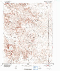
1953 Map of Berry Sand Draw
USGS Topo · Published 1955About this map
Berry Sand Draw cuts through the high plains of the Texas Panhandle in this mid-century topographic record. The landscape is defined by deep drainage systems like Box Canyon and the confluence of numerous watercourses, including Coetas Creek and Chicken Creek. Human presence in this environment appears largely transitory or historical, marked by the Berry Ranch (Aband) and Wright Ranch (Aband). Industrial and military footprints are visible through the Chicago Rock Island and Pacific railroad line and the US Army Rifle Range (Aband). Small-scale resource extraction is evidenced by the Caliche Quarries near the southern boundary. The presence of Pretty Spring and other unnamed springs suggests the vital role of water sources in this dry terrain, which dictated the placement of these early ranching and military outposts.
Find a feature on this map
20 named features on this map. Tap any name to fly to it.
Don’t see what you’re looking for? This feature index may not catch every label — zoom into the map to look around manually.
Map Details
Editions of this 1953 Berry Sand Draw Map
2 editions found

Other maps of this area

1934 · Cliffside
USGS Topo · 1:62,500

1936 · Fourways
USGS Topo · 1:62,500

1936 · Cliffside
USGS Topo · 1:62,500

1939 · Sanford
USGS Topo · 1:62,500

1953 · Chunky
USGS Topo · 1:24,000

1953 · Alibates Ranch
USGS Topo · 1:24,000

1953 · Pleasant Valley
USGS Topo · 1:24,000

1953 · Deal
USGS Topo · 1:24,000

1953 · Mayer
USGS Topo · 1:24,000

1953 · McDowell Creek
USGS Topo · 1:24,000