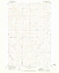
1965 Map of Berry School
USGS Topo · Published 1968About this map
The Redwater River winds through this mid-1960s landscape, marking a sparsely populated region of eastern Montana where the boundary between McCone County and Prairie County cuts across the plains. The map reveals a community structured around small country institutions, notably the namesake Berry School and Wilson Sch. This area, while largely open terrain, shows the essential markers of rural Montana life during the mid-century, including the Watkins Ch and adjacent Watkins Cem located near the intersection of various ranch trails and local roads. Drainage patterns are defined by the river and its tributaries like Hay Creek and Lisk Cr, illustrating the vital water sources for the cattle operations that have long anchored this high plains economy. The presence of the Schlinker landmark further anchors the local topography for those tracing family history in this frontier landscape.
Find a feature on this map
12 named features on this map. Tap any name to fly to it.
Don’t see what you’re looking for? This feature index may not catch every label — zoom into the map to look around manually.
Map Details
Editions of this 1965 Berry School Map
This is the sole edition of this map. No revisions or reprints were ever made.
Other maps of this area

1954 · Jordan
USGS Topo · 1:250,000

1954 · Glendive
USGS Topo · 1:250,000

1956 · Jordan
USGS Topo · 1:250,000

1957 · Glendive
USGS Topo · 1:250,000

1958 · Jordan
USGS Topo · 1:250,000

1958 · Glendive
USGS Topo · 1:250,000

1964 · Jordan
USGS Topo · 1:250,000

1965 · Hedstrom Lake
USGS Topo · 1:24,000

1965 · Hedstrom Lake SE
USGS Topo · 1:24,000

1965 · Heitz School
USGS Topo · 1:24,000