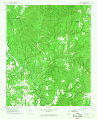
1967 Map of Berry SE
USGS Topo · Published 1968About this map
The North River meanders through the heart of this landscape along the border of Fayette and Tuscaloosa Counties, serving as a primary drainage for numerous streams like Tyro Creek and Bear Creek. In the late 1960s, this rural area was defined by its scattered community centers, characterized by a series of small country churches and cemeteries that anchored local life. Places like Union Grove Ch, Liberty Hill Ch, and Sulphur Springs Ch appear alongside family-named sites such as Willingham Cem and Utley Cem. The presence of the Gorgas Sch in the southwest corner and Witton Bridge over the river highlights the essential infrastructure of this period. Notable topography includes Poplar Hollow and the drainage of Little Yellow Creek, showing a terrain largely dedicated to forestry and small-scale agriculture before significant modern development altered the region.
Find a feature on this map
29 named features on this map. Tap any name to fly to it.
Don’t see what you’re looking for? This feature index may not catch every label — zoom into the map to look around manually.
Map Details
Editions of this 1967 Berry SE Map
4 editions found
Other maps of this area

1893 · Jasper
USGS Topo · 1:125,000

1899 · Brookwood
USGS Topo · 1:125,000

1926 · Samantha
USGS Topo · 1:48,000

1928 · Samantha
USGS Topo · 1:62,500

1929 · Searles
USGS Topo · 1:48,000

1934 · Searles
USGS Topo · 1:62,500

1949 · Oakman
USGS Topo · 1:24,000

1949 · Wiley
USGS Topo · 1:24,000

1951 · Oakman
USGS Topo · 1:24,000

1951 · Wiley
USGS Topo · 1:24,000