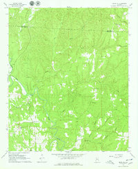
1967 Map of Berry SE
USGS Topo · Published 1979About this map
The winding North River meanders through the boundary of Fayette Co and Tuscaloosa Co in this late 1960s topographical study. This part of Alabama is defined by a dense network of creek valleys and ridges, where small rural communities are anchored by landmarks like Gorgas Sch and several country churches including Union Grove Ch and Liberty Hill Ch. The landscape is heavily marked by family-named burial grounds, such as Johnson Cem, Fairview Cem, and Willingham Cem, which are tucked away near the many tributaries like Tyro Creek and Bear Creek. The presence of the Wittson Bridge and the Oregonia Ch near the southern edge of the sheet reflects the established settlement patterns of this river-valley region before major modern redevelopment.
Find a feature on this map
28 named features on this map. Tap any name to fly to it.
Don’t see what you’re looking for? This feature index may not catch every label — zoom into the map to look around manually.
Map Details
Editions of this 1967 Berry SE Map
4 editions found
Other maps of this area

1893 · Jasper
USGS Topo · 1:125,000

1899 · Brookwood
USGS Topo · 1:125,000

1926 · Samantha
USGS Topo · 1:48,000

1928 · Samantha
USGS Topo · 1:62,500

1929 · Searles
USGS Topo · 1:48,000

1934 · Searles
USGS Topo · 1:62,500

1949 · Oakman
USGS Topo · 1:24,000

1949 · Wiley
USGS Topo · 1:24,000

1951 · Oakman
USGS Topo · 1:24,000

1951 · Wiley
USGS Topo · 1:24,000