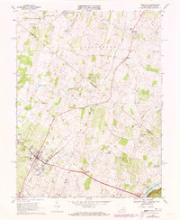
1968 Map of Berryville
USGS Topo · Published 1973About this map
Berryville serves as the focal point of this northern Shenandoah Valley landscape, situated at the intersection of critical transit corridors including the Norfolk and Western and Baltimore and Ohio railroads. The 1968 survey details a region deeply rooted in its local institutions, evidenced by the numerous community landmarks like the County High School, Cooley School, and Johnson-Williams High School. To the east, the Shenandoah River flows past the Holy Cross Monastery and the golf course, while the northern reaches of the quadrangle cross into West Virginia near Summit Point. The terrain is defined by a dense network of watercourses including Bullskin Run, Marsh Run, and Dog Run, which dictated the placement of historic settlements like Rippon, Gaylord, and Wickliffe. Genealogists will find significant value in the mapped locations of Green Hill Cemetery, Milton Valley Cemetery, and Prosperity Cemetery.
Find a feature on this map
45 named features on this map. Tap any name to fly to it.
Don’t see what you’re looking for? This feature index may not catch every label — zoom into the map to look around manually.
Map Details
Editions of this 1968 Berryville Map
4 editions found
Other maps of this area

1884 · Harpers Ferry
USGS Topo · 1:125,000

1891 · Harpers Ferry
USGS Topo · 1:125,000

1893 · Harpers Ferry
USGS Topo · 1:125,000

1894 · Winchester
USGS Topo · 1:125,000

1914 · Martinsburg
USGS Topo · 1:48,000

1914 · Gerrardstown
USGS Topo · 1:48,000

1916 · Gerrardstown
USGS Topo · 1:62,500

1916 · Martinsburg
USGS Topo · 1:62,500

1916 · Berryville
USGS Topo · 1:62,500

1937 · Gerrardstown
USGS Topo · 1:48,000