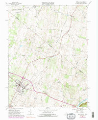
1968 Map of Berryville
USGS Topo · Published 1981About this map
The Shenandoah River flows through the southeastern corner of this landscape, where the Cool Spring park area and the Holy Cross Monastery sit near the riverbank. This 1960s survey, updated in the late 1970s, captures a region defined by established agricultural tracts and a network of small, scattered communities like Jamestown, Rippon, and Wickliffe. The town of Berryville serves as a primary hub, showing concentrated residential development around the County Fairground and educational centers like Johnson-Williams High Sch.
Find a feature on this map
48 named features on this map. Tap any name to fly to it.
Don’t see what you’re looking for? This feature index may not catch every label — zoom into the map to look around manually.
Map Details
Editions of this 1968 Berryville Map
4 editions found
Other maps of this area

1884 · Harpers Ferry
USGS Topo · 1:125,000

1891 · Harpers Ferry
USGS Topo · 1:125,000

1893 · Harpers Ferry
USGS Topo · 1:125,000

1894 · Winchester
USGS Topo · 1:125,000

1914 · Martinsburg
USGS Topo · 1:48,000

1914 · Gerrardstown
USGS Topo · 1:48,000

1916 · Gerrardstown
USGS Topo · 1:62,500

1916 · Martinsburg
USGS Topo · 1:62,500

1916 · Berryville
USGS Topo · 1:62,500

1937 · Gerrardstown
USGS Topo · 1:48,000