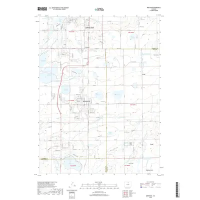
2019 Map of Berthoud
USGS Topo · Published 2019About this map
The Little Thompson River carves through this agricultural corridor, defining a landscape heavily shaped by early 20th-century water engineering. The dense network of irrigation systems, including the Handy Ditch, Old Ish Ditch, and Rockwell Ditch, supports the farming communities between Loveland and Mead. This infrastructure allowed for the development of several small settlements and industrial waypoints, most notably Berthoud and the community of Campion. Numerous storage bodies like Loveland Reservoir and Handy Reservoir punctuate the plains, while Greenlawn Cem serves as a central genealogical focal point for the region. The map also captures specialized transport and terrain features, from the Skylane Ranch Airport to the distinctive local topography of Twin Mounds and Big Owl Hill.
Find a feature on this map
156 named features on this map. Tap any name to fly to it.
Don’t see what you’re looking for? This feature index may not catch every label — zoom into the map to look around manually.
Map Details
Editions of this 2019 Berthoud Map
This is the sole edition of this map. No revisions or reprints were ever made.
Other maps of this area

1902 · Greeley
USGS Topo · 1:125,000

1904 · Niwot
USGS Topo · 1:62,500

1906 · Loveland
USGS Topo · 1:62,500

1908 · Loveland
USGS Topo · 1:62,500

1949 · Gowanda
USGS Topo · 1:24,000

1950 · Gowanda
USGS Topo · 1:24,000

1950 · Windsor
USGS Topo · 1:24,000

1950 · Hygiene
USGS Topo · 1:24,000
1950 · Longmont
USGS Topo · 1:24,000

1950 · Johnstown
USGS Topo · 1:24,000