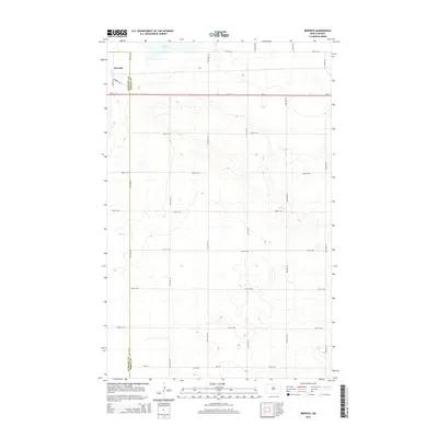
2014 Map of Berwick
USGS Topo · Published 2014About this map
The settlement of Berwick sits at the northern edge of this North Dakota landscape, situated just west of the McHenry Co and Pierce Co boundary line. This high plains terrain is defined by its rectilinear road grid, which segments the prairie into square sections for agricultural use. Primary access is provided by Us-2, which cuts a straight line across the northern third of the map, intersected by local routes like Berwick Trl and Berwick Ln. In the far north, the presence of Rush Lake provides a natural break in the otherwise systematic township and range organization. The elevation contours reveal the subtle undulations typical of the region's glaciated geology, where small depressions and rises dictate the placement of rural homesteads and farmsteads along numbered corridors such as 16th Ave NE and 60th St NE.
Find a feature on this map
24 named features on this map. Tap any name to fly to it.
Don’t see what you’re looking for? This feature index may not catch every label — zoom into the map to look around manually.
Map Details
Editions of this 2014 Berwick Map
This is the sole edition of this map. No revisions or reprints were ever made.
Other maps of this area

1954 · Tunbridge
USGS Topo · 1:24,000

1954 · Towner NE
USGS Topo · 1:24,000

1954 · Berwick
USGS Topo · 1:24,000

1954 · Round Lake
USGS Topo · 1:24,000

1954 · Leverich
USGS Topo · 1:24,000

1954 · Towner SE
USGS Topo · 1:24,000

1954 · Minot
USGS Topo · 1:250,000

1955 · Rangeley NE
USGS Topo · 1:24,000

1958 · Minot
USGS Topo · 1:250,000
1958 · Balta NW
USGS Topo · 1:24,000