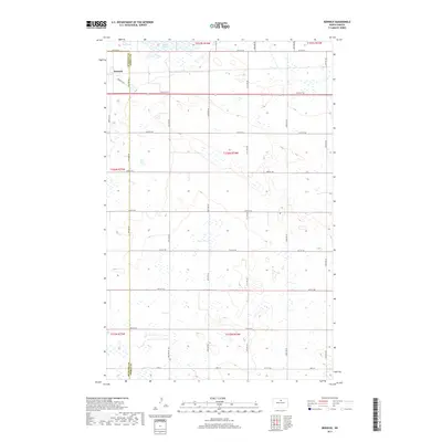
2017 Map of Berwick
USGS Topo · Published 2017About this map
Berwick sits at the edge of a vast prairie landscape defined by the boundary between McHenry Co and Pierce Co in north-central North Dakota. This 2017 survey reveals a strictly organized grid of agricultural roads, including 65th St NE and 20th Ave NE, which partition the terrain into precise sections. In the northern reaches, the waters of Rush Lake interrupt the section lines, surrounded by a network of seasonal wetlands and small basins that characterize the glacial drift plain. The presence of Berwick Trl and Berwick Ln near the town site provides a clear view of how local transit has adapted to the traditional township and range system. This map captures the modern state of a region where the economy remains deeply tied to the land and its drainage patterns.
Find a feature on this map
28 named features on this map. Tap any name to fly to it.
Don’t see what you’re looking for? This feature index may not catch every label — zoom into the map to look around manually.
Map Details
Editions of this 2017 Berwick Map
This is the sole edition of this map. No revisions or reprints were ever made.
Other maps of this area

1954 · Tunbridge
USGS Topo · 1:24,000

1954 · Towner NE
USGS Topo · 1:24,000

1954 · Berwick
USGS Topo · 1:24,000

1954 · Round Lake
USGS Topo · 1:24,000

1954 · Leverich
USGS Topo · 1:24,000

1954 · Towner SE
USGS Topo · 1:24,000

1954 · Minot
USGS Topo · 1:250,000

1955 · Rangeley NE
USGS Topo · 1:24,000

1958 · Minot
USGS Topo · 1:250,000
1958 · Balta NW
USGS Topo · 1:24,000