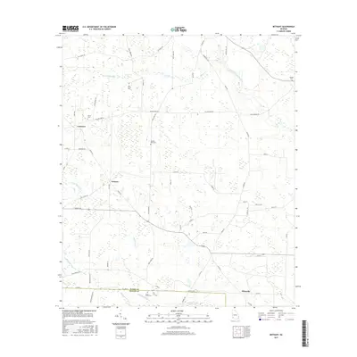
2017 Map of Bethany
USGS Topo · Published 2017About this map
Bethany and Mimsville anchor this rural Georgia landscape, where the Baker and Miller County line divides a terrain defined by winding watercourses and small family landmarks. The northeastern corner is shaped by the broad path of Ichawaynochaway Creek, while the western reaches are drained by Alligator Cr and the various branches of Little Cypress Cr. This 2017 survey details a network of local roads such as Bainbridge Hwy and Rentz Bridge Rd that connect isolated settlements and several notable burial sites. Genealogists may find value in the specific locations of the Stephen Bush Cem, Oak Grove Cem, and Cedar Grove Cem, which suggest long-standing community roots. The landscape remains largely agricultural and forested, with numerous wetlands scattered throughout the low-lying areas between Crestview and the county border.
Find a feature on this map
56 named features on this map. Tap any name to fly to it.
Don’t see what you’re looking for? This feature index may not catch every label — zoom into the map to look around manually.
Map Details
Editions of this 2017 Bethany Map
This is the sole edition of this map. No revisions or reprints were ever made.
Other maps of this area

1953 · Dothan
USGS Topo · 1:250,000

1954 · Dothan
USGS Topo · 1:250,000

1955 · Dothan
USGS Topo · 1:250,000

1956 · Newton
USGS Topo · 1:62,500

1971 · Hopeful
USGS Topo · 1:24,000

1974 · Damascus
USGS Topo · 1:24,000

1974 · Arlington
USGS Topo · 1:24,000

1974 · Cooktown
USGS Topo · 1:24,000

1974 · Elmodel
USGS Topo · 1:24,000
1974 · Colquitt
USGS Topo · 1:24,000