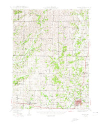
1948 Map of Bethany
USGS Topo · Published 1948About this map
Bethany serves as the focal point of this Harrison County survey, where the Chicago Burlington and Quincy railroad cuts through the southern landscape to connect the county seat with New Hampton. The terrain is defined by the intricate branching of Big Creek and its many tributaries, including Little Big Creek and the West Fork Big Creek. This network of waterways historically dictated the placement of dozens of one-room schoolhouses and rural meeting places, such as the Zimmerman Sch and Mt Olive No 2 Ch.
Find a feature on this map
83 named features on this map. Tap any name to fly to it.
Don’t see what you’re looking for? This feature index may not catch every label — zoom into the map to look around manually.
Map Details
Editions of this 1948 Bethany Map
4 editions found

Other maps of this area

1925 · Pattonsburg
USGS Topo · 1:62,500

1925 · Gilman
USGS Topo · 1:62,500

1925 · Darlington
USGS Topo · 1:62,500

1940 · Blockton
USGS Topo · 1:62,500

1942 · Grant City
USGS Topo · 1:62,500

1943 · Grant City
USGS Topo · 1:62,500

1943 · Blockton
USGS Topo · 1:62,500

1944 · Pattonsburg
USGS Topo · 1:62,500

1945 · Mount Ayr
USGS Topo · 1:62,500

1945 · Lamoni
USGS Topo · 1:62,500