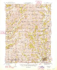
1948 Map of Bethany
USGS Topo · Published 1948About this map
Bethany serves as the focal point of this Northwest Missouri landscape, situated where the Chicago Burlington and Quincy railroad line meets the forks of Big Creek. The map reveals a dense agricultural network of the mid-1940s, marked by an exceptional number of rural schools like Pebble Ridge Sch and Muddy Valley Sch spaced nearly every few miles. Local governance and social services are anchored by the County Farm and Washington Center, while industrial infrastructure appears via the Great Lakes Pumping Sta south of New Hampton. The terrain is defined by the drainages of the West Fork Big Creek and East Fork Big Creek, which dictated the placement of early settlements like Martinsville. Numerous country cemeteries and churches, including Hillebaum Cem and Oakland Ch, provide precise location data for genealogical research in Harrison County.
Find a feature on this map
83 named features on this map. Tap any name to fly to it.
Don’t see what you’re looking for? This feature index may not catch every label — zoom into the map to look around manually.
Map Details
Editions of this 1948 Bethany Map
4 editions found

Other maps of this area

1925 · Pattonsburg
USGS Topo · 1:62,500

1925 · Gilman
USGS Topo · 1:62,500

1925 · Darlington
USGS Topo · 1:62,500

1940 · Blockton
USGS Topo · 1:62,500

1942 · Grant City
USGS Topo · 1:62,500

1943 · Grant City
USGS Topo · 1:62,500

1943 · Blockton
USGS Topo · 1:62,500

1944 · Pattonsburg
USGS Topo · 1:62,500

1945 · Mount Ayr
USGS Topo · 1:62,500

1945 · Lamoni
USGS Topo · 1:62,500