
1945 Map of Mount Ayr
USGS Topo · Published 1954About this map
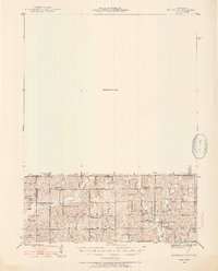
The borderlands of southern Iowa and northern Missouri are defined by a network of drainage basins including Lotts Creek and Big Creek as they flow through Lincoln and Hamilton townships. This 1945 survey captures a traditional rural landscape characterized by a high density of small-scale community landmarks. Settlements like Hatfield and Pawnee serve as local hubs, while the map reveals a system of rural education through widely distributed institutions such as Turkey Grove Sch, Lincoln Center Sch, and Smith Sch. The social fabric of the mid-century border country is further highlighted by family and congregational landmarks like Petry Cem and Lotts Grove Ch. While the southern portion of the map is meticulously detailed, the northern half remains a notable Unsurveyed Area, creating a stark contrast in the recorded geographic data of the period.
Find a feature on this map
28 named features on this map. Tap any name to fly to it.
Don’t see what you’re looking for? This feature index may not catch every label — zoom into the map to look around manually.
Map Details
Editions of this 1945 Mount Ayr Map
2 editions found
Other maps of this area

1940 · Blockton
USGS Topo · 1:62,500

1942 · Grant City
USGS Topo · 1:62,500

1943 · Grant City
USGS Topo · 1:62,500

1943 · Blockton
USGS Topo · 1:62,500

1945 · Lamoni
USGS Topo · 1:62,500

1947 · Lamoni
USGS Topo · 1:62,500

1947 · Blythedale
USGS Topo · 1:62,500

1947 · Mount Ayr
USGS Topo · 1:62,500

1948 · Bethany
USGS Topo · 1:62,500

1954 · Centerville
USGS Topo · 1:250,000