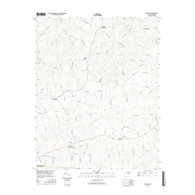
2016 Map of Bethany
USGS Topo · Published 2016About this map
Wentworth and the surrounding rural communities of Rockingham County characterize this landscape at the edge of the Guilford County line. The terrain is defined by the headwaters of several notable drainage systems, including the southward-flowing Haw River and the meandering paths of Troublesome Creek and Huffines Mill Creek. Small-scale aviation is represented by the Mountain View Aerodrome, while the road network connects established rural centers like Bethany, Midway, and Bakers Crossroads. This area demonstrates a persistent pattern of rural North Carolina settlement, where crossroads communities serve as anchors for family farms and timber tracts. Researchers will find numerous namesake roads and geographic features such as Rock House Creek and Simpsons Lake that reflect long-standing local history and land ownership in the Piedmont region.
Find a feature on this map
103 named features on this map. Tap any name to fly to it.
Don’t see what you’re looking for? This feature index may not catch every label — zoom into the map to look around manually.
Map Details
Editions of this 2016 Bethany Map
This is the sole edition of this map. No revisions or reprints were ever made.
Other maps of this area

1951 · Lake Brandt
USGS Topo · 1:24,000

1951 · Browns Summit
USGS Topo · 1:24,000

1953 · Greensboro
USGS Topo · 1:250,000

1954 · Greensboro
USGS Topo · 1:250,000

1962 · Greensboro
USGS Topo · 1:250,000

1966 · Greensboro
USGS Topo · 1:250,000

1969 · Summerfield
USGS Topo · 1:24,000
1971 · Mayodan
USGS Topo · 1:24,000
1971 · Southeast Eden
USGS Topo · 1:24,000
1971 · Ellisboro
USGS Topo · 1:24,000