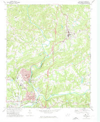
1971 Map of Mayodan
USGS Topo · Published 1974About this map
The confluence of the Mayo River and Dan River anchors this study of north-central Rockingham County during the early 1970s. The urban centers of Madison and Mayodan are shown in significant detail, revealing a dense grid of residential streets, industrial infrastructure like the Filtration Plant, and municipal landmarks including the Town Hall and Library. The Norfolk and Western railroad tracks parallel the river valley, serving the local economy and connecting these textile and manufacturing towns to the broader region. North of these hubs, the landscape transitions toward Stoneville, characterized by a more dispersed settlement pattern and several community focal points like Glens Chapel and the Stoneville Sch. The rugged terrain near Cedder Mtn and the presence of the Avalon Dam illustrate how the local topography has been utilized for recreation and industry. Genealogists will find value in the well-marked rural sites, such as Llewellyn Cem and Deep Springs Ch.
Find a feature on this map
39 named features on this map. Tap any name to fly to it.
Don’t see what you’re looking for? This feature index may not catch every label — zoom into the map to look around manually.
Map Details
Editions of this 1971 Mayodan Map
This is the sole edition of this map. No revisions or reprints were ever made.
Other maps of this area

1924 · Martinsville
USGS Topo · 1:48,000

1926 · Martinsville
USGS Topo · 1:62,500

1926 · Critz
USGS Topo · 1:48,000
1927 · Martinsville
USGS Topo · 1:62,500

1928 · Critz
USGS Topo · 1:62,500

1944 · Martinsville
USGS Topo · 1:62,500

1953 · Winston-Salem
USGS Topo · 1:250,000

1953 · Greensboro
USGS Topo · 1:250,000

1954 · Greensboro
USGS Topo · 1:250,000

1955 · Winston-Salem
USGS Topo · 1:250,000