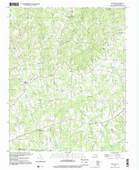
1997 Map of Bethany
USGS Topo · Published 2000About this map
Troublesome Creek and its many tributaries, including Huffines Mill Creek and Rock House Creek, dominate the rural topography of this Rockingham County landscape. The settlement pattern is defined by several prominent junctions such as Wittys Crossroads, Bakers Crossroads, and the village of Bethany. The southern edge of the sheet follows the Haw River along the boundary with Guilford County, where Glencoe Ch sits just north of the water. Local social life is anchored by numerous country churches, including Antioch Ch, Smyrna Ch, and Sharon Ch. A local High Sch and Water Tank at Bethany indicate the community's development by the late 20th century. Utility infrastructure is noted by a prominent network of pipelines running north-to-south through the center of the survey area.
Find a feature on this map
33 named features on this map. Tap any name to fly to it.
Don’t see what you’re looking for? This feature index may not catch every label — zoom into the map to look around manually.
Map Details
Editions of this 1997 Bethany Map
This is the sole edition of this map. No revisions or reprints were ever made.
Other maps of this area

1951 · Lake Brandt
USGS Topo · 1:24,000

1951 · Browns Summit
USGS Topo · 1:24,000

1953 · Greensboro
USGS Topo · 1:250,000

1954 · Greensboro
USGS Topo · 1:250,000

1962 · Greensboro
USGS Topo · 1:250,000

1966 · Greensboro
USGS Topo · 1:250,000

1969 · Summerfield
USGS Topo · 1:24,000
1971 · Mayodan
USGS Topo · 1:24,000
1971 · Southeast Eden
USGS Topo · 1:24,000
1971 · Ellisboro
USGS Topo · 1:24,000