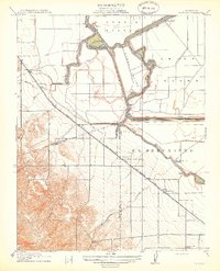
1914 Map of Bethany
USGS Topo · Published 1914About this map
The lowlands of the San Joaquin River delta meet the rising foothills near Bethany in this 1914 topographic survey. This landscape is defined by the complex aquatic network of Old River and Italian Slough, where reclaimed lands like Victoria Island and Union Island are protected by intricate embankments. The map captures a moment when the region relied on both waterborne transport at White House Landing and Bethany Ferry, and the expanding rail power of the Southern Pacific RR and the San Francisco and New Orleans Line.
Find a feature on this map
27 named features on this map. Tap any name to fly to it.
Don’t see what you’re looking for? This feature index may not catch every label — zoom into the map to look around manually.
Map Details
Editions of this 1914 Bethany Map
2 editions found
Other maps of this area

1907 · Tesla
USGS Topo · 1:62,500

1911 · Byron Hot Springs
USGS Topo · 1:31,680

1913 · Woodward Island
USGS Topo · 1:31,680

1913 · Holt
USGS Topo · 1:31,680

1914 · Brentwood
USGS Topo · 1:31,680

1914 · Bethany
USGS Topo · 1:31,680

1914 · Union Island
USGS Topo · 1:31,680

1916 · Byron Hot Springs
USGS Topo · 1:31,680

1916 · Byron
USGS Topo · 1:62,500

1916 · Tracy
USGS Topo · 1:31,680