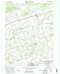
1992 Map of Bethel
USGS Topo · Published 1995About this map
Bethel and the surrounding agricultural valleys of Berks and Lebanon Counties are defined by a complex network of creeks and early industrial landmarks. The landscape is bisected by Little Swatara Creek and Tulpehocken Creek, which supported historic milling operations at places like Crosskill Mills. A significant cultural marker is the Union Canal near Millardsville, illustrating the era's reliance on inland waterways for transport. The map reveals a dense settlement pattern of small crossroads and family-named landmarks, including Merkey Ch and Zeigler Ch. Local social and recreation hubs are well-represented, from the Shikellamy Scout Camp in the north to the Hilltop Park Speedway near Kutztown. This survey effectively preserves the layout of these rural townships before late-twentieth-century expansions altered the traditional character of the Pennsylvania Dutch Country.
Find a feature on this map
48 named features on this map. Tap any name to fly to it.
Don’t see what you’re looking for? This feature index may not catch every label — zoom into the map to look around manually.
Map Details
Editions of this 1992 Bethel Map
This is the sole edition of this map. No revisions or reprints were ever made.
Other maps of this area

1889 · Pottsville
USGS Topo · 1:62,500

1891 · Pottsville
USGS Topo · 1:62,500

1891 · Lebanon
USGS Topo · 1:62,500

1892 · Pine Grove
USGS Topo · 1:62,500

1893 · Lebanon
USGS Topo · 1:62,500

1899 · Lebanon
USGS Topo · 1:62,500

1902 · Wernersville
USGS Topo · 1:62,500

1943 · Lebanon
USGS Topo · 1:62,500

1943 · Wernersville
USGS Topo · 1:62,500

1945 · Friedensburg
USGS Topo · 1:24,000
Featured Places
- Bethel Township, PA
- Myerstown, PA
- Jackson Township, PA
- Millardsville, Jackson Township
- Nacetown, Jackson Township