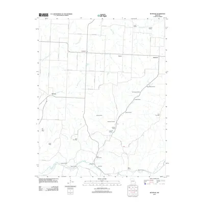
2012 Map of Bethpage
USGS Topo · Published 2012About this map
Bethpage and Longview anchor this Missouri landscape, where the plateau surface is deeply dissected by a dense network of hollows and ridges. The topography is defined by the winding course of Big Sugar Creek in the south and the headwaters of Elkhorn Creek to the west. Evidence of local industry and natural resources appears in names like Lime Kiln Hollow and Elkhorn Springs, while the ridge-and-valley system is clearly delineated by features such as Blue Clay Ridge and Chase Ridge.
Find a feature on this map
66 named features on this map. Tap any name to fly to it.
Don’t see what you’re looking for? This feature index may not catch every label — zoom into the map to look around manually.
Map Details
Editions of this 2012 Bethpage Map
This is the sole edition of this map. No revisions or reprints were ever made.
Other maps of this area

1916 · Neosho
USGS Topo · 1:62,500

1940 · Noel
USGS Topo · 1:62,500

1941 · Rocky Comfort
USGS Topo · 1:62,500

1943 · Ritchey
USGS Topo · 1:62,500

1943 · Noel
USGS Topo · 1:62,500

1943 · Rocky Comfort
USGS Topo · 1:62,500

1954 · Tulsa
USGS Topo · 1:250,000

1958 · Tulsa
USGS Topo · 1:250,000

1963 · Tulsa
USGS Topo · 1:250,000
1972 · Wheaton
USGS Topo · 1:24,000