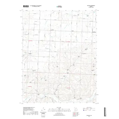
2017 Map of Bethpage
USGS Topo · Published 2017About this map
Bethpage and the small settlements of Longview, Simcoe, and Bethlehem anchor this pocket of McDonald County. The landscape is defined by a dense network of hollows and ridges, reflecting a deeply carved topography where local names like Stillhouse Hollow, Lime Kiln Hollow, and Blue Clay Hollow hint at the historical land use and resource extraction of the Ozark plateau. Water sources are abundant, from the major flow of Big Sugar Creek and Mikes Creek in the south to specific points like Elkhorn Springs and Hanken Spring. Long-established ridges such as Old Foot Ridge, Blue Clay Ridge, and Pine Log Ridge serve as natural dividers between the drainage basins of Elkhorn Creek and its branches. This modern survey from the U.S. Geological Survey details how rural roads like Possum Hollow Road and Mikes Creek Road follow these narrow valleys, maintaining a transport pattern long dictated by the terrain.
Find a feature on this map
62 named features on this map. Tap any name to fly to it.
Don’t see what you’re looking for? This feature index may not catch every label — zoom into the map to look around manually.
Map Details
Editions of this 2017 Bethpage Map
This is the sole edition of this map. No revisions or reprints were ever made.
Other maps of this area

1916 · Neosho
USGS Topo · 1:62,500

1940 · Noel
USGS Topo · 1:62,500

1941 · Rocky Comfort
USGS Topo · 1:62,500

1943 · Ritchey
USGS Topo · 1:62,500

1943 · Noel
USGS Topo · 1:62,500

1943 · Rocky Comfort
USGS Topo · 1:62,500

1954 · Tulsa
USGS Topo · 1:250,000

1958 · Tulsa
USGS Topo · 1:250,000

1963 · Tulsa
USGS Topo · 1:250,000
1972 · Wheaton
USGS Topo · 1:24,000