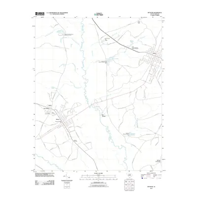
2011 Map of Bethune
USGS Topo · Published 2011About this map
The Lynches River meanders southward through this South Carolina landscape, defining the corridor between the established railroad towns of Bethune and McBee. This era shows a region shaped by its water sources and historical routes, where old thoroughfares like Old Wire Rd and Wire Rd trace paths through the timber and farmland of Chesterfield and Kershaw counties. Local genealogy and history are anchored by long-standing landmarks such as the Bethel Cemetery and Sandy Level Cemetery, while the McBee Lookout Tower stands as a sentinel over the surrounding forests.
Find a feature on this map
85 named features on this map. Tap any name to fly to it.
Don’t see what you’re looking for? This feature index may not catch every label — zoom into the map to look around manually.
Map Details
Editions of this 2011 Bethune Map
This is the sole edition of this map. No revisions or reprints were ever made.
Other maps of this area

1941 · Spartanburg
USGS Topo · 1:250,000

1953 · Spartanburg
USGS Topo · 1:250,000

1960 · Spartanburg
USGS Topo · 1:250,000

1963 · Spartanburg
USGS Topo · 1:250,000

1964 · Spartanburg
USGS Topo · 1:250,000

1967 · Angelus
USGS Topo · 1:24,000

1967 · Mount Pisgah
USGS Topo · 1:24,000

1968 · Middendorf
USGS Topo · 1:24,000
1968 · Lake Robinson
USGS Topo · 1:24,000

1968 · Kellytown
USGS Topo · 1:24,000