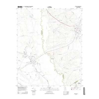
2014 Map of Bethune
USGS Topo · Published 2014About this map
Lynches River carves a winding path through the center of this landscape, serving as the natural boundary between Kershaw and Chesterfield counties. The town of Bethune stands as a primary hub of settlement, defined by a grid of streets such as North Main Street and West College Street, while the nearby community of McBee occupies the northeast corner. This 2014 survey documents a region defined by its water resources, from the expansive Little Lynches River in the southwest to the historic Hough Millpond and Blackwell Millpond. Genealogists and local historians can pinpoint significant burial sites including Sandy Level Cemetery, Brannon Cemetery, and Bethel Cemetery. The rural character of the area is further evidenced by scattered locales like Big Springs, Baxley, and McCoys Crossroads, illustrating a long-standing pattern of South Carolina crossroads and creek-side settlements.
Find a feature on this map
96 named features on this map. Tap any name to fly to it.
Don’t see what you’re looking for? This feature index may not catch every label — zoom into the map to look around manually.
Map Details
Editions of this 2014 Bethune Map
This is the sole edition of this map. No revisions or reprints were ever made.
Other maps of this area

1941 · Spartanburg
USGS Topo · 1:250,000

1953 · Spartanburg
USGS Topo · 1:250,000

1960 · Spartanburg
USGS Topo · 1:250,000

1963 · Spartanburg
USGS Topo · 1:250,000

1964 · Spartanburg
USGS Topo · 1:250,000

1967 · Angelus
USGS Topo · 1:24,000

1967 · Mount Pisgah
USGS Topo · 1:24,000

1968 · Middendorf
USGS Topo · 1:24,000
1968 · Lake Robinson
USGS Topo · 1:24,000

1968 · Kellytown
USGS Topo · 1:24,000