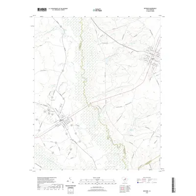
2020 Map of Bethune
USGS Topo · Published 2020About this map
The Lynches River and its expansive wetlands form a winding natural boundary between Kershaw and Chesterfield counties, anchoring a landscape shaped by slow-moving water and traditional mill sites. Historically significant water bodies like Hough Millpond and Blackwell Millpond indicate the region's reliance on creek-driven industry, while the Little Lynches River carves through the southern terrain. This 2020 survey documents the primary settlements of Bethune and McBee, showing the grid-like residential growth and surrounding agricultural roads. Genealogists will find several notable burial sites preserved here, including Sandy Level Cem and Bethel Cem near Bethune, as well as the more secluded Brannon Cem. The map provides a contemporary view of these established Sandhills communities, from the residential streets of McBee to the rural corridors like Old Creek Rd and Sowell Town Rd.
Find a feature on this map
90 named features on this map. Tap any name to fly to it.
Don’t see what you’re looking for? This feature index may not catch every label — zoom into the map to look around manually.
Map Details
Editions of this 2020 Bethune Map
This is the sole edition of this map. No revisions or reprints were ever made.
Other maps of this area

1941 · Spartanburg
USGS Topo · 1:250,000

1953 · Spartanburg
USGS Topo · 1:250,000

1960 · Spartanburg
USGS Topo · 1:250,000

1963 · Spartanburg
USGS Topo · 1:250,000

1964 · Spartanburg
USGS Topo · 1:250,000

1967 · Angelus
USGS Topo · 1:24,000

1967 · Mount Pisgah
USGS Topo · 1:24,000

1968 · Middendorf
USGS Topo · 1:24,000
1968 · Lake Robinson
USGS Topo · 1:24,000

1968 · Kellytown
USGS Topo · 1:24,000