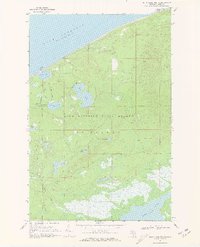
1968 Map of Betsy Lake North
USGS Topo · Published 1970About this map
Lake Superior dominates the northern horizon of this coastal survey, where the lighthouse at Crisp Point stands as a lonely sentinel over the shoreline. Located within the Lake Superior State Forest, this region of McMillan is characterized by an intricate network of inland water bodies and wetlands. The map details the winding courses of the Two Hearted River and the Little Two Hearted River as they thread through a landscape punctuated by Culhane Lake, Bodi Lake, and the expansive Betsy Lake to the south.
Find a feature on this map
22 named features on this map. Tap any name to fly to it.
Don’t see what you’re looking for? This feature index may not catch every label — zoom into the map to look around manually.
Map Details
Editions of this 1968 Betsy Lake North Map
2 editions found
Other maps of this area

1951 · Vermilion
USGS Topo · 1:24,000

1951 · Sheephead Lake
USGS Topo · 1:24,000

1951 · Timberlost
USGS Topo · 1:24,000

1951 · Shelldrake
USGS Topo · 1:62,500

1954 · Sault Sainte Marie
USGS Topo · 1:250,000

1956 · Sault Sainte Marie
USGS Topo · 1:250,000

1957 · Sault Sainte Marie
USGS Topo · 1:250,000

1958 · Sault Sainte Marie
USGS Topo · 1:250,000

1968 · Betsy Lake NW
USGS Topo · 1:24,000

1968 · Betsy Lake SW
USGS Topo · 1:24,000