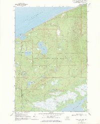
1968 Map of Betsy Lake North
USGS Topo · Published 1971About this map
Crisp Point stands as a prominent landmark on the northern edge of the Lake Superior State Forest, where a historic Lighthouse overlooks the shoreline of Lake Superior. The interior of the quadrangle is defined by a dense network of glacial lakes and wetlands, including Culhane Lake, Bodi Lake, and the expansive Betsy Lake at the southern boundary. These water bodies are connected by a complex hydrology of small streams and rivers, such as the Little Two Hearted River and Threemile Creek. Surveyed in the late 1960s, the landscape reveals a remote wilderness character where infrastructure is limited to the Little Lake Harbor Road and various Jeep Trails. The presence of several Campgrounds and a Gravel Pit near the coast suggests a region managed for both recreational access and local resource extraction within the state forest boundaries.
Find a feature on this map
24 named features on this map. Tap any name to fly to it.
Don’t see what you’re looking for? This feature index may not catch every label — zoom into the map to look around manually.
Map Details
Editions of this 1968 Betsy Lake North Map
2 editions found
Other maps of this area

1951 · Vermilion
USGS Topo · 1:24,000

1951 · Sheephead Lake
USGS Topo · 1:24,000

1951 · Timberlost
USGS Topo · 1:24,000

1951 · Shelldrake
USGS Topo · 1:62,500

1954 · Sault Sainte Marie
USGS Topo · 1:250,000

1956 · Sault Sainte Marie
USGS Topo · 1:250,000

1957 · Sault Sainte Marie
USGS Topo · 1:250,000

1958 · Sault Sainte Marie
USGS Topo · 1:250,000
1968 · Betsy Lake North
USGS Topo · 1:24,000

1968 · Betsy Lake NW
USGS Topo · 1:24,000