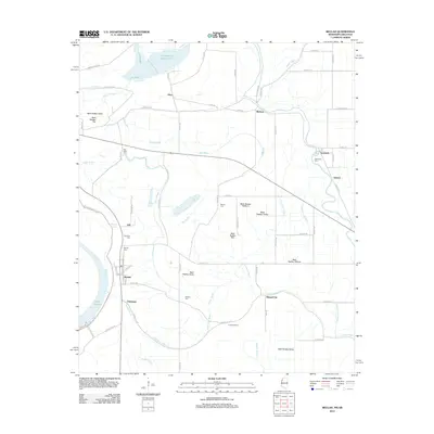
2012 Map of Beulah
USGS Topo · Published 2012About this map
The Mississippi River Levee anchors the western edge of this landscape, shielding the low-lying agricultural plains of Bolivar County. This 2012 survey illustrates a highly engineered environment where natural water bodies like Lake Beulah and Bogue Phalia coexist with an extensive drainage network, including Ditch Number Seven and Ditch Number Nine. Small settlements and family-named landmarks are scattered throughout the delta, notably Beulah, Mound City, and Niles. Local history and genealogy researchers will find several rural burial grounds preserved across the townships, such as Scotland Cem, Beulah Cem, and Waldon Cem. The proximity of Chenault Farms and Christmas to the meandering course of Half Moon Bayou reflects the traditional relationship between the region's fertile soils and its dispersed residential clusters.
Find a feature on this map
55 named features on this map. Tap any name to fly to it.
Don’t see what you’re looking for? This feature index may not catch every label — zoom into the map to look around manually.
Map Details
Editions of this 2012 Beulah Map
This is the sole edition of this map. No revisions or reprints were ever made.
Other maps of this area

1933 · Lamont
USGS Topo · 1:62,500

1939 · Pace
USGS Topo · 1:62,500

1939 · Big Island
USGS Topo · 1:62,500

1939 · Lamont
USGS Topo · 1:62,500

1939 · Choctaw
USGS Topo · 1:62,500

1953 · Greenwood
USGS Topo · 1:250,000

1956 · Greenwood
USGS Topo · 1:250,000
1967 · Skene
USGS Topo · 1:24,000

1967 · Lobdell
USGS Topo · 1:24,000
1969 · Choctaw
USGS Topo · 1:62,500