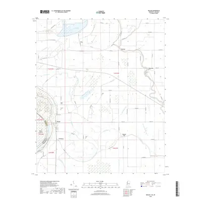
2018 Map of Beulah
USGS Topo · Published 2018About this map
Lake Beulah and its surrounding wetlands dominate this landscape along the state border where the Arkansas Mississippi line weaves through the alluvial plains of the Delta. The settlement of Beulah sits on the interior of the oxbow lake, serving as a hub for a network of rural communities including Mound City, Malvina, and Symonds. This region is defined by a complex hydrography of bayous and sloughs, such as Bogue Phalia, Laban Bayou, and Half Moon Bayou, which dictate the placement of roads and farmsteads.
Find a feature on this map
75 named features on this map. Tap any name to fly to it.
Don’t see what you’re looking for? This feature index may not catch every label — zoom into the map to look around manually.
Map Details
Editions of this 2018 Beulah Map
This is the sole edition of this map. No revisions or reprints were ever made.
Other maps of this area

1933 · Lamont
USGS Topo · 1:62,500

1939 · Pace
USGS Topo · 1:62,500

1939 · Big Island
USGS Topo · 1:62,500

1939 · Lamont
USGS Topo · 1:62,500

1939 · Choctaw
USGS Topo · 1:62,500

1953 · Greenwood
USGS Topo · 1:250,000

1956 · Greenwood
USGS Topo · 1:250,000
1967 · Skene
USGS Topo · 1:24,000

1967 · Lobdell
USGS Topo · 1:24,000
1969 · Choctaw
USGS Topo · 1:62,500